Once out of New York harbour, we made a right turn to follow the New Jersey coast, a long strip of white sand populated with beach homes and seaside resorts.
 |
| New Jersey beaches |
Given that we had been protected from wind and waves since Lake Ontario, we had become slackers in terms of battening down for heavy seas. As we rocked and rolled down the coast, unbeknown to us until later, we lost our nice new aluminum deck brush and my favourite gardening stool from Lee Valley, both of which shot overboard off the middle deck where they were stowed without “gimmiwaddles” (Michael and Sandra’s term for bungee cords).
My herb garden also pitched off its perch on the aft step and landed face down on the deck doing significant damage to my beloved basil. Oh dear, lesson learned! I then staggered around the pitching decks securing things like a farmer closing the barn door after the horses had bolted.
We arrived at Barnegat Inlet and made our way to an aptly named anchorage called Refuge Harbor. We sought advice from SeaTow, an organization that we joined for towing insurance should we run aground. They also provide local knowledge for getting into difficult places. This was a good thing as there was considerable shifting of shoals in the harbor.
The catamaran entering ahead of us ran aground and needed a lot of assistance to get off. We, on the other hand, touched bottom briefly but David managed to get us off with a spurt of power and some fancy steering. We stirred up some mud but safely arrived at our anchorage (L39o 45.4’N Lo 074o 7.2’W).
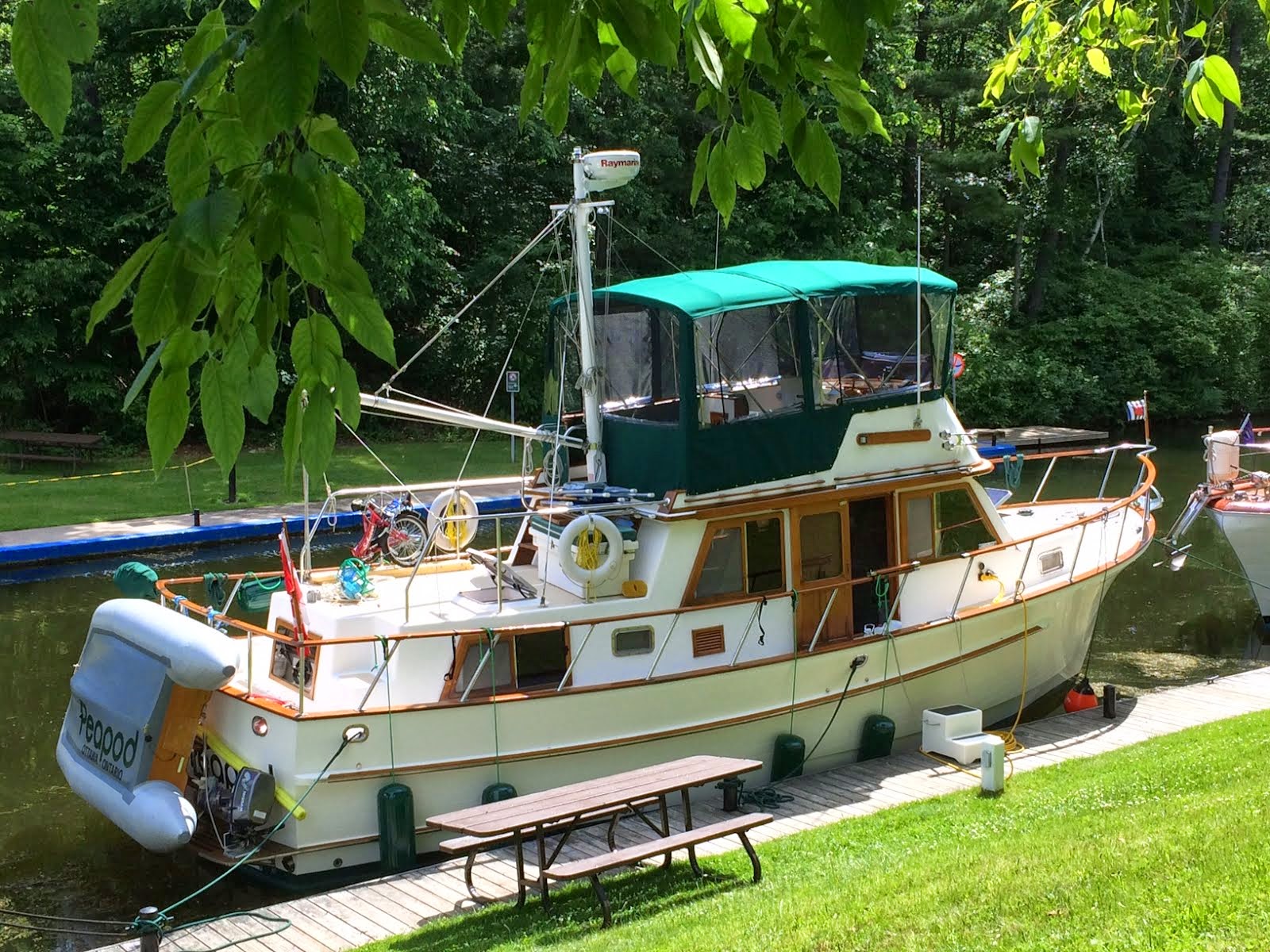
We enjoyed another lovely quiet evening on the hook. One of the highlights was the arrival of a gorgeous Bayfield 32, which we consider a family boat as David’s dad, my brother Michael, and our dear friends Sandra and Michael are all Bayfield sailors.
 |
| Barnegat Inlet |
 |
| Barnegat light |
 |
| Beautiful Bayfield in golden light |
The morning of July 22nd dawned clear and calm and we set off again down the coast, this time with all moveable objects tied fast! New Jersey seems to be nothing but miles and miles of sandy beach. Who knew? Our plan was to stop at Atlantic City but wind and waves were in our favour. It was just after noon when we approached the city famous for its boardwalks and gambling, so we decided to give it a miss and carry on. We saw our first pod of porpoises frolicking around our boat, quite a thrill, but we were too slow to get pictures.
 |
| Atlantic City skyline |
 |
| Trump's Taj Mahal |
We made it all the way to Cape May, a record-breaking 88-mile day, and tied up at Utsch’s Marina recommended by cruising friends. We were welcomed by wonderfully helpful dock staff boasting that their community was the nation’s oldest and best seaside resort.
The next morning David called our internet/phone provider (Telus) to unlock his iPhone. We had been very frustrated by the cost and poor service of their roaming plan. We’ve all heard of the crazy stories about astronomical roaming charges and were simply fed up. They obliged by unlocking his phone so he could install a new U.S. SIM card from T-Mobile. However, he had to back up his phone and then restore it using the Internet. Unfortunately, the marina’s free Wi-Fi was so poor that it would have taken him at least 30 minutes standing in the bathroom foyer where the signal was strongest.
So, back we biked to town in search of high speed Internet at the public library. Their service predicted it would take four hours!! So I researched the local businesses and found an Internet café that sounded like good coffee at the very least. When we got there, their high speed was so fast, he accomplished his task in 5 minutes!!
Then off to the local pharmacy (CVS carries everything!) to buy a SIM card kit to install on his phone. That was the good news. The bad news was that on our return to the boat, he discovered that it was meant for an iPhone 4 and we have iPhone 5’s. No problem said David, ever the problem-solver. To my horror he went at the card with a pair of scissors, cut it to fit and filed it down with a nail file!! He is such a handyman it scares me!
Our next trip to town on the bikes was for groceries and wine (yes, Mum, we were out of wine again). We rode back to the boat to stow our provisions. Our third ride of the day took us to Cape May’s amazing beach. By the time we arrived, the crowds had gone home and we had the shore pretty much to ourselves. There were big rollers and we played in the wild surf, just like the “old days” at Ingonish Beach in Nova Scotia except that the water was warm! The homes along the shore are spectacular.
 |
| Cute new bikes and Captain Dave |
 |
| Modest Cape May home |
 |
| Gorgeous beach |
 |
| Just before I fell over |
 |
| Happy captain |
 |
| Wonderful seaside home |
As a last hurrah in Cape May we decided to ride to the famous Sunset Beach, home of the concrete shipwreck and the WW2 tower that was used in conjunction with others of its kind to triangulate positions of enemy ships off the coast. There were crowds gathering on the beach to watch the sun go down. Unlike the other sandy beaches along the coast, this one was made of small pebbles made smooth by generations of waves on this remote point of land.
 |
| WWII tower |
 |
| Fishing and cement boat |
 |
| Sunset beach pebbles |
We figure we had ridden at least 15 miles that day by the time we were done and decided to treat ourselves to dinner at the famous Lobster House, a Cape May institution since 1922, just a short walk from the boat. We were pretty sandy so went to the marina showers to clean up. I was horrified to find buckets of sand in my bathing suit, which ended up in the toilet and didn’t flush away…how embarrassing! I finally got the sand out of my hair in the shower after a double shampoo. All fresh and tarted up we strolled over and had a wonderful meal, pretty much closing the place.
 |
| A treat! |
 |
| Wonderful bread |
The next morning, July 24th, dawned with a light rain. We were undeterred as we had our new fly bridge cover. We had decided to go on “the outside” rather than entering the Intracoastal Waterway at this point. The Delaware and Chesapeake Bays are a beautiful cruise but 80 miles longer than going along the Atlantic coast and we were still feeling the pressure of our repair delays.
 |
| Refuge Harbor |
 |
| Sunset at Refuge Harbor |
The next day dawned clear and the 3-day forecast looked good for an outside journey to Norfolk so we decided to take the risk in the interest of making up time. David rigged up our little steadying sail to mitigate the rock ‘n roll at sea. It was a beautiful day with wind and waves in our favour.
We were “surfing” at 10 knots, a record for our little Peapod engine (Perkins 135 diesel)! We came up on Ocean City NJ, our planned destination, just after noon. Again, we decided to continue and did a quick course correction to a small inlet further down the coast.
 |
| Ocean City |
As we approached our alternate destination, we decided to call SeaTow again for local knowledge given the scary reviews of this inlet in our cruising guide. The fellow I spoke was adamant that we mustn’t enter this inlet under any circumstances given shoaling that was unpredictable around the entrance. “That place is nothing but sand and sea turtles…just don’t go there!”
So at 5PM we had a dilemma – to go another 6 hours along this sandy island to Cape Charles on Chesapeake Bay or to find another place to tuck in. We decided to go to the next bay – Wachapreague Inlet - another 20 nautical miles south where we felt more confident about the safety of the approach.
So after 10 hours and 98 miles –a new record - we approached this inlet. The closer we got the less we liked the look of it, which was plagued with sandy shoals just like the rest of this whole coast. However, we were not prepared for a night sail to the Chesapeake Bay. So we decided not to enter the inlet but to anchor outside on Parramore Beach (L37o 33.1N Lo 075o 36.6’W). We were protected for the most part from the prevailing winds but were still rocked through the night by swells off the ocean, which definitely affected our sleep.
 |
| Desolate Parramore Beach |
After a rolly night we were up early and spent the day with the wind in our teeth. We passed by more miles and miles of sand, much of which was a national park with the only human habitation being a few spunky campers along the never-ending beach.
We also passed through an area just north of Chesapeake Bay where there was a massive fish kill with bodies of thousands of 8-10” fish floating on the surface. It was very disturbing (and smelly) and there was no obvious explanation.
Crossing the mouth of the Chesapeake Bay was quite an adventure. First, it was choppy and windy. Second, it was full of boats, from little fishing vessels to giant freighters and warships. As we approached Norfolk, Virginia the Coast Guard came on the VHF radio with a dangerous weather warning. There were violent thunderstorms in the area with possible waterspouts. Small craft were advised to seek shelter. Eeek! We were going as fast as possible toward Norfolk Harbor and couldn’t squeeze any more knots out of little diesel.
 |
| Chesapeake ship |
As we entered the harbour, we passed by the largest naval base in the world, obviously of interest to the two navy brats aboard. I took lots of pictures of ships, mostly for the sake of my Dad who will no doubt know more about them than I do, despite his Alzheimer’s. We also saw huge container ships up close and personal, and intrepid sailors darting out of their way. We watched with awe as the skillful tug pilots worked in tandem to nudge one of these monsters into the container port for unloading.
 |
| Destroyer and enormous hospital ship |
 |
| What does this ship do? |
 |
| Busy tandem tugs |
 |
| Brave sailor |
Thankfully, we dodged the storm bullet and dropped anchor in the lee of Hospital Point on the Portsmouth side of the harbor (L36o 50.8”N Lo 076o 18.1’W). Hospital Point is home to a huge naval hospital complex serving active members and veterans and employing over 5,000 people.
After another long and challenging day at sea (10 hours and 78 miles) we were happy to have a quiet evening on board and watch the distant storm clouds that had passed us by. Across the Elizabeth River, there is a beautiful waterfront park where free concerts are held and we were treated to live music again.
On Sunday morning after breakfast we set out in the dinghy with our knapsacks, lists, rolling grocery cart and our ponchos, as there was rain in the forecast. There is a free dinghy dock next to the WW2 battleship Wisconsin, which was crawling with families taking advantage of the free tours.
 |
| The Wisconsin |
On our 5-mile mile walk, we encountered the first of many mermaids, which seemed to be a city theme, kind of like the moose statues in Toronto. It reminded me that I didn’t let Rachel see the Disney film “The Littlest Mermaid” because she gave up her life in the sea for a man. What kind of a mother was I to deprive my daughter of such a fantasy?
 |
| Norfolk mermaid |
The city was ablaze with exotic trees that we couldn’t identify. We would later learn that they were Crepe Myrtle.
 |
| Crepe Myrtle |
Another highlight was the biggest wine store we’ve ever seen (yes, Mum, we were out of wine again). We stocked up with advice from a very helpful young man who knew his wines. It would have taken us hours to wander through this massive warehouse without his help.
 |
| Giant wine store |
Nearby was a fabulous supermarket where we stocked up on fresh food and milk. Loaded to the gunwales, we limped back to the dinghy and almost made it before the rain hit. Fortunately it was just a shower and we spent the evening on the deck watching some British sailors who were trying in vain to anchor.
They kept dropping their hook in water that was way too deep and then wondered why they were dragging into the shipping channel. After three tries, they passed close to us and David called out that they should move in closer to shore. Of course, we commented to each other that they obviously hadn’t taken their Seamanship course as we had done through the Canadian Power and Sailing Squadron in Ottawa.
Well, they took him quite literally and moved in so close they were in the middle of a mooring field. Their anchor held but we didn’t stick around the next day to see whether they were all snarled up in the mooring ball lines. Free entertainment!
We also watched the fun in the park. First there was a children’s dance event with fairies, princes and princesses flitting around. Then, at dusk, there was another concert with a rock band. We watched our favourite tour boat go out for its sunset cruise.
.JPG) |
| Schooner sunset cruise |
As it returned after dark, we could hear a solo musician with a guitar serenading us with Neil Young’s “Harvest Moon”. We were so excited that David gave a big catcall and I jumped around like a goof holding out our Canadian flag. I’m sure the people on board didn’t know Neil was Canadian and thought we were just a pair of crazy Canuks!
That night we enjoyed a delicious grilled
lamb chop with fresh rosemary from our boat garden.
 |
| Another gourmet dinner on board |
Speaking of the garden, after she fell on her face out in the ocean, the basil started to show signs of frailty. I think the trauma and the salt spray were the culprits, and possibly the boat’s bleach-treated drinking water. I sure hope I can find another basil plant, as our favourite salad is summer tomatoes with basil and fresh buffalo mozzarella…yum.
The sad tale is illustrated by the before and after pictures.
 |
| The before |
 |
| The after |
The next morning, July 28th, we set off on our first leg of the Intracoastal Waterway (ICW). This is a series of rivers, canals and bays that connect Cape May, New Jersey to the southernmost tip of Florida. It allows safe passage for vessels as an alternative to the open ocean and its associated weather risks. One of the down sides is that some areas are very narrow and shallow, and many a recreational boater has found him/herself stuck in the mud while attempting to avoid a collision with one of the many barges that ply the waterway. This is why we heeded the advice of many boater friends and took out towing insurance. Thankfully we haven’t needed it yet, but I am knocking on wood as I write this.
The other challenge is timing for the openings of low bridges. Our first day in the ICW, aptly nicknamed “the ditch”, we encountered six of these and one lock. They have scheduled opening times, some twice an hour and some only once an hour. In a couple of cases, we were just a little too slow and the bridge masters will not wait for slowpokes even if they can see you’re only moments away. So we ended up going in circles while we waited for the next opening.
 |
| Beautiful lock |
 |
| More Crepe Myrtle |
For most of the day we were passing though marshes with plenty of bird life and no other souls. Nearly every channel marker had an Osprey’s nest in it with you families. If we came too close, the parents would squeak madly and try to dive bomb us.
 |
| Mad osprey |
Given all of the stopping and starting, and a shortage of suitable anchorages, we travelled only 31 miles that day. We snuck into Blackwater Creek, Virginia (L 36o 35.9’N Lo 076o 04’W) with considerable trepidation as we had read reports that the entrance was very shallow. Indeed it was! We crept along at nearly idle speed, watching in horror as the depth sounder counted down from 5 feet to 1.9 feet. Given that we theoretically draw 4 feet, this was a bit scary. However, our sounding device is calibrated to read the water depth under the keel so it really meant that there was 1.9 feet of wiggle room – still less than desirable!
We finally found a small patch of 8-foot water and dropped the hook into the mud (it wasn’t called Blackwater Creek for nothing!) in a tiny area surrounded by 10-foot marsh grass. The mud bubbled and gurgled, and just as we were getting ready for a cold one, we looked back and realized we were much closer to the grasses than we had been. We were dragging…argh. So we fired up the engine and tried twice more before we got a good set.
By this time we were hot and sweaty so jumped into the creek for a swim in the lukewarm water. As we climbed up the swim ladder we noticed a cute little snake wrapped around our stern thruster. David gave him a poke with the swim noodle to dislodge him but he came right back. I wonder what the attraction was and whether he’s still there, as we haven’t had to use our thruster since.
 |
| Swimming in the creek |
 |
| Glossy crayfish snake |
 |
| Beautiful swamp |
 |
| Sunset in the swamp |
We were all alone in the creek, which was a good thing. There certainly wouldn’t have been room for another boat to anchor. We enjoyed a jolly boatload of locals out for a sunset ride on a pontoon boat. As they roared around the corner at a great rate of speed we held our collective breath, afraid they wouldn’t see us tucked into the grasses. Thankfully they did and veered around our stern, laughing and waving. When they returned later in the evening they were even more enthusiastic, yelling “YAY” at the top of their lungs and waving madly. There must have been a pub at the end of the creek.
We had a beautiful evening. The water was like glass and there was a cacophony of frog sounds, which were almost unbelievably loud. We had the best sleep so far on the trip and awakened in the morning to the sound of fighter jets from Norfolk passing over us. It was a fine wake-up call and we were underway early with a plan to get to the Alligator River in North Carolina, 55 miles away.
 |
| Coinjock eatery |
We only had Internet connectivity for a nanosecond along this route. When we did, I seized the opportunity to order a battery charger for my favourite camera (I brought the wrong one) and to reserve a slip at a marina three days away. They kindly agreed to accept my parcel. We will have been 7 straight days on the hook by then, which is great because it’s free. However, it’s a nice treat to have laundry facilities and a real shower as an alternative to our miniature boat shower.
We crossed the Albermarle Sound with blue skies and light winds. This was a very good thing, as it is a very large, shallow (10-15 feet) body of water that can kick up quite a chop in windy conditions. Even so, it was surprisingly choppy with the odd whitecap and took a lot of steering to stay on course.
We accessed the anchorage at Alligator River (L35o 56.4’N Lo075o 55.9’W) by navigating through a gazillion crab pots, marked by tiny buoys. These represent a real hazard, as you sure don’t want to get your propeller wrapped around the buoy lines. It was literally like picking your way through a minefield.
I was at the helm and David was on watch. We use our computer at the helm station for the nautical charts and every so often the screen goes to sleep. In the moment it took me to tap the pad to wake it up, David yelled “red buoy dead ahead!!” and I had to make a quick course direction to avoid it without aiming for another one. Talk about stressful!!
We finally dropped the hook on the very edge of what we fondly called crab city. The fishermen had used almost every foot of available space up to where the charts showed 2 feet of water! We managed to find 5 feet of depth with just enough swinging room to avoid a buoy encounter. We had another gourmet dinner, red sunset and gorgeous crescent moon. Since we left civilization, the night sky has been so dark and the stars so brilliant.
 |
| The chef |
 |
| The dinner |
 |
| Red sky at night |
 |
| Crescent moon |
On July 30th we proceeded down the Alligator River with only one bridge, which opened on request. It was an enormous span with a centre platform that rapidly swung open to let us through. We were still under it when the operator began to close it again, like a cranky host giving his guests the bum’s rush. It wasn’t as if it was a busy superhighway either, with just a handful of vehicles waiting to cross.
 |
| Alligator River bridge |
From there the river narrowed considerably. Eventually we entered the canal portion, built to bypass the wiggly snakelike route of the natural watercourse. I’m afraid the U.S. Army Corps of Engineers was more concerned with efficiency than aesthetics, as it was built straight as an arrow through miles and miles of scrub and marsh. It seemed we were hardly moving as we pointed the bow into what seemed like infinity, with nothing to distract the eye. The landscape was perfectly flat and frankly quite boring. I don’t wish to malign North Carolina; I’m sure it’s beautiful along the coast and elsewhere. Just not here.
The only sign of civilization was the unusual sight of a fuel and seafood establishment.
 |
| Fishing boat and strange combo business |
After 7 days at anchor, we were delighted to arrive at the most luxurious marina we have ever seen - Grace Harbor at River Dunes. It is located in Broad Creek, just north of Oriental, North Carolina. The employees were wonderful as they took our lines and did everything possible to make life easy for us. They offer a pool with a bar, Jacuzzi, showers, laundry, restaurant, courtesy car and spectacular surroundings for an extremely reasonable price. Just the ticket after travelling 386 miles.
 |
| The marina "office" |
 |
| The pool bar |
 |
| Rick offering free welcome beers |
 |
| Relaxing in the Jacuzzi |